Wednesday, October 5, 2011

Tiger

This past Saturday my hiking partner and I summited Mt. Princeton - one of Colorado's many 14'ers. Hitting the trail probably an hour late meant that we had light and lovely weather on the ascent, but a stormy and fast descent. Here are two pictures relaying the climb up and down, showing the weather that had moved in.


Summiting involved working through much scree. First, wrapping alongside the basin, then along a ridge-line, and, finally, up a very steep slope that was exhausting.


Upon reaching the summit we noticed that a storm that had been moving to the northeast had veered off course, and was suddenly headed directly towards us. We'd been watching the storm clouds develop and had been ready to head down as soon as things got sketchy. However, the combination of pretty and seemingly innocuous clouds (see picture below), as well as a prevailing wind moving in the other direction made a summit attempt seem doable.

Soon, snow was falling, and our stay on the summit was literally less than two minutes long.

Having a good sense that staying exposed was not a wise course of action, we made our way down very quickly. Hearing thunder bursts directly overhead, lightning strikes coming down by the summit, my partner's hair standing on end due to the static electricity in the air, and the panicked descents off-trail of hikers behind us was unnerving to say the least. In retrospect, an earlier start would have been a lot wiser. Next 14'er, I suppose.

Wednesday, September 28, 2011

Fall in the Rockies


Having spent my college days in New England, I am well-versed in the vibrancy and fire of the fall. The high-country of Colorado provides something of a different palette, however. In many ways more muted, yes, but still quite stirring.

The aspens in autumn are most akin to the changing colors of an eastern fall. But not having to compete with other deciduous trees, their gold blazes flash across mountainsides with a bright and singular ferocity.

The changing colors of alpine flora are the most subtle. This area, above treeline, is so hardy and delicate that I'm always taken aback with the slight changes in color that take place at this time of year. It is as if the grasses and plants and shrubs would prefer to explode into the bright colors of their brethren aspen, were it not for having to focus on merely surviving.


So the earthen autumnal tones of Naomi Wolf reign supreme here. And while much less intense, they are as moving as the bright reds, oranges, and yellows of the northeast.

Tuesday, September 27, 2011

Below the Diamond

Having failed to summit Longs, I decided to extend my hike and take my lunch at Chasm Lake.


Chasm Lake lies directly to the east of Longs Peak - immediately underneath the Diamond. This sheer face rises a sheer 1000' directly to the summit. It, no doubt, represents Longs Peak like no other element. It was first climbed in 1960 (the ascent taking two days), and today has a multiple classic routes. It's an iconic part of local climbing lore.

Surrounding Chasm Lake are a number of imposing peaks and formations, including Mt. Meeker to the south. Perhaps fittingly, given its name, Meeker misses out on being a 14'er by a mere 89'. This striking formation is the 'Ship's Prow' - and, like the Diamond, also sits right on top of Chasm Lake.


All in all, a perfect place to ponder the high country whilst eating my peanut butter and honey sandwich. Others, it seems, were also taking time to figure out what was going on. As with my friends the marmots, this little fella should not be confused for a micro-beaver - but rather it's a pika. Fully grown, they are 6-9" long, and live amongst the rocks, tallus, and scree. Like their cousins the marmots, they make high-pitched noises to warn their neighbors of strangers in their midst.


Monday, September 26, 2011

Longs Way

Today I tried to summit Longs Peak. For good or for bad I wasn't successful. Longs Peak, as you may know, is the only 14,000'er in this part of the state. In addition to being a [relatively] very tall mountain, it's also a very tough climb. Summiting Longs involves a 7 mile hike from trailhead to summit, and significant elevation gain. As a result, one must begin very early. This morning, I was on the trail at 3:45 am.

These are two pictures taken as the Sun was rising.


Summiting Longs Peak involves stamina - due to the distance, as well as a willingness to deal with heights and the long descent if one places a foot in the wrong place. Approaching from the east, one first has to cross the 'Boulder Field.' The first picture below looks back across this boulder-strewn slope. At the top of the Boulder Field is the 'Keyhole' - the second picture, below. This gap allows you to access the trail (the 'Narrows') on the back, or western side of Longs Peak.


Normally, as soon as one makes ones way through the Keyhole one is buffeted by extremely strong winds. Not today, however. Instead one simply stepped from the brightness of a warming sun, to the still graying dawn of a narrow ledge with a drop-off of what must have been two or three thousand feet. 


The final approach on Longs is known as the 'Trough.' Unbeknownst to me, the summit had received nearly a foot and a half of snow last week. The remnants of that remained still in the Trough - resulting in very tiring and fairly unstable footing. What little path there normally is was covered by snow and ice. Where there was none, only loose stones and steep stones remained. As a result of this unstable footing and the potential for slipping, about halfway up, I made the decision that the mountain would still be here next year...


This is a picture of the Trough and one of its climbers. Unfortunately, the picture doesn't capture the pitch involved.

Sunday, September 25, 2011

99

As a dad, this fall has been quite the game-changer. In the space of a month our eldest has begun school, and also begun playing on her first team sport.

Especially for girls, I think being part of a team is absolutely instrumental in a healthy growing-up. Reaching back to the college days, some of those for who I have the fondest memories - and who I respect most of all - are those who played team sports. Whether my kids end up playing for the fun of it, or receiving scholarships from CU or Stanford is completely besides the point. Instead, I would rather take away the benefits that camaraderie and exercise will provide.

Activities


As I've mentioned to folks many times in conversation, one of the things I love about Boulder is the proximity of things to do. A combination of a city that is concerned about providing its populace with options for entertainment and cultural connection with recreational opportunities makes for days that sometimes include more choices than hours.

A few weeks ago, I was presented with one of these situations. The kids had wanted to do the famous 'Squeeze Rock' hike (known to most others in the area as the Red Rocks hike. This particular trail is literally 3 minutes drive from the center of town. The combination of a hike with rocks to climb on makes it a favorite.

That said, a post-squeeze-snack may compete for what is actually the favorite part of the hike.

Following the 'Squeeze Rock' hike, we went downtown to the Boulder Hometown Festival. I have absolutely no sense what differentiates this festival from other Boulder Creek-side festivals. But... they did have zucchini car racing!! Perhaps this ostensibly small-town America activity makes it a Hometown Festival???

The kids absolutely loved their zucchini cars. -- even when they began rotting and literally breaking apart on the inside of the house days later...

Saturday, September 3, 2011

12-5K

Last night I spent the evening on Pawnee Pass, in Indian Peaks. While camping is not allowed in the eastern part of the wilderness area - given its popularity and the potential for high impact - one can camp on the western part of the Pass. Leaving work yesterday, I busted through town, made my way up to the trailhead, and was on the trail by 6:30. Sunset was officially at 7:30, so I knew I had to make good time to be on the pass before it was too dark. The last parts of the hike are the steepest - I knew that I didn't want to be tackling scree and snowfields without any daylight at all.

I made it up to the top in 1hr 45 mins. Slow-going, on the one hand, as that's only a pace of 26 min/mile. On the other - given the conditions - I was moving along nearly as fast as I've hiked yet - so I was happy with my time. Towards the end of the hike I was bathed in alpenglow, and then worked my way forward through the murky grey of the early evening. By the time I got to the top, it was nearly completely dark out. Stumbling around on the saddle of the Pass, I was absolutely exhausted. I finally found a good place to set up camp in a little hollow of grass with rocks large and small on all sides.

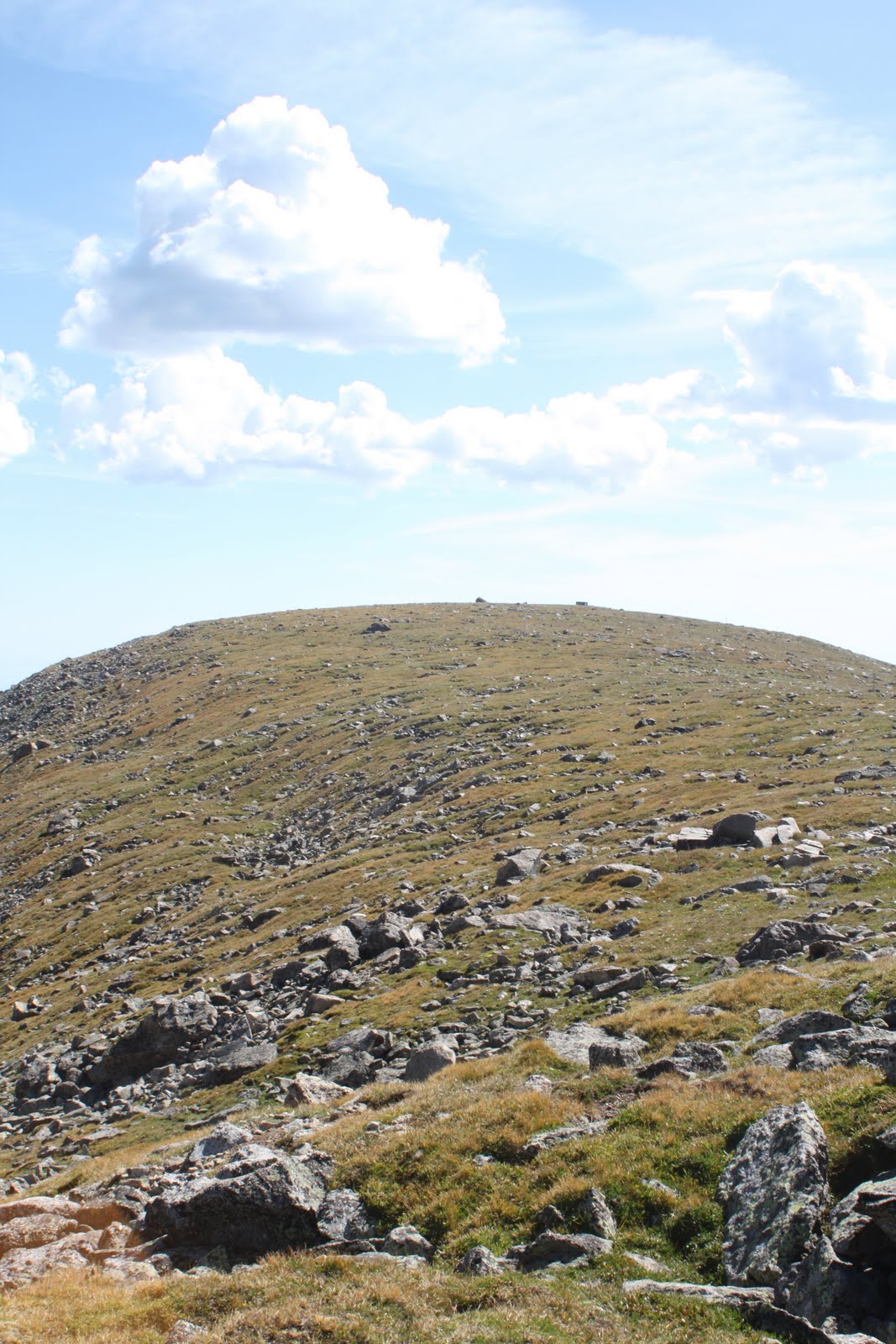
Pawnee Pass tops out at 12,550 feet. That, in combination with fierce winds ripping over the Divide, made for a very cold evening. While my water didn't freeze, the temperature must have been just above freezing. At the trailhead at 10 this morning, with the sun high in the sky and over 2,000' lower in elevation, the temperature was 46 degrees.  So, for all my compatriots who were at sea level last night - we had very different night's sleep!


The scenery was spectacular. Looking east I could see the lights of Boulder and Denver and a fierce lightning storm erupting over them. To the west, I could make out Grand Lake and the scattered lights of the smalls towns surrounding it. This morning, a blanket of clouds covered Grand Lake - like it had been tucked in for the night. And the stars, as you might expect, fiercely pin-pricked the sky above (that is, when I dared peek out of my bag...)

Going forward - if one is thinking about sleeping above treeline - here are my thoughts. DON'T begin your hike an hour before sunset. DON'T decide that you don't really need a tent when the jetstream seems to be about 2' above your head...


(apologies for the quality of the pic - the camera ran out of power)

 And most importantly, DON'T use the sleeping bag your mother gave you in 1989 that seems not only threadbare and has down falling out of it, but must be rated for the frigid temperature of 85 degrees...!

That said, DO, do it again.

Ride Rabbit Ride!

A week ago, today, I got to see Stage 5 of the USA Pro Cycling Challenge. This leg went from Steamboat Springs to Breckenridge. Mick, myself, and some other old friends watched the race from halfway up Rabbit Ears Pass - the big mountain pass that leads out of (or into, depending on which way you're traveling) Steamboat. After a few miles of rolling roads leading out of town, the cyclists were hit with a massive climb. We knew that while it was relatively close to the start, the nature of the climb meant that the peloton would break apart fairly quickly - offering lots of viewing opportunities.


Spectators were situated the entire way up the climb. Even a few hours before the riders came through, the atmosphere was very festive - with fans decked out in all manner of gear.


Signaled by a convoy of police vehicles and rider support cars, the energy of the crowd began building even before any of the riders were in sight.


And, as was the case a few days earlier, it was exhilarating seeing these top-level athletes literally only a few feet away. This is the leader, and the lead pack at this stage in the race. You'll see Levi Leipheimer - who eventually won the overall race - in the yellow in this picture.


 And here is another picture of Cadel Evans (note the rainbow stripes on his sleeve - signifying he has won a world championship).


Sunday, August 28, 2011

ITT

My good mate, Mick, and I spent the past few days watching the USA Pro Cycling challenge here in Colorado.


What an event!! Not only was this the first serious cycling race I'd been to - but a number of international-class teams and riders were racing. This includes Cadel Evans - the winner of the 2011 Tour de France -


 as well as the Schleck brothers - who came 2nd and 3rd in this year's tour. So, needless to say, a lot of talent riding the roads of Colorado this August! These pictures are of one of the cyclists rounding a curve in Vail Village at the beginning of the course - just a few seconds out of the start.


Thursday's stage consisted of an individual time trial beginning in Vail. While 'just' 10 miles, it entailed a climb of 1,700 feet. Pretty brutal when you're already beginning at an elevation of 8,000 feet. This time trial is actually a classic route - it was one of the mainstays of the Coors Classic race a number of years past. The great thing about an individual time trial is that each rider has to ride by himself. Spaced apart by a minute each, this meant we got to watch over 3 hours of top-level riders. This made for a great and exciting afternoon of watching top-level sports.


Vail did a great job in hosting the stage. Already a place where I've had some of my most favorite and unforgettable experiences, this event has only added to my appreciation of the town. Great place to carouse with good friends, have a pint, and watch some great sports.


Moot Point

Moots is a Steamboat Springs-based bike company. In addition to building nationally-recognized bikes in a tiny town, the key thing about Moots is that it builds nothing but very high end Ti bikes.

And this is what I want...


However, given the Vamoots RSL's current retail price of over $8700, it seems I'm going to have to wait to make this purchase for just a little while.... In the meantime, to satiate your and my interest in fine rides, here are some of their other new bikes.


JT3 - any second-hand deals you want to make - you let me know!

Sunday, August 21, 2011

THIS is not a beaver!

Today I hiked the Niwot Ridge trail in the Indian Peaks Wilderness Area. At the top, my hiking partners and I were greeted by one of the local marmot residents.


While the original plan was to hike the Arapahoe Glacier trail, it turns out that trail is closed till next year because of trail maintenance concerns (please, please don’t raise our taxes – the nation’s infrastructure and resources really don’t need maintaining….).


While not the original plan, this hike was great. Ambling over rolling alpine terrain we eventually made our way to a narrow ridgeline that led west to the Divide. Given gathering stormclouds, we didn’t make it the whole way up the ridge. That said, the old wise marmot (attested by his silver fur) encouraged me to return – and suggested that some of my eastern readership might appreciate coming along for a walk. I guarantee that you’ll enjoy the hike as much as my hiking buddy (although you’ll have to bring your own smokes!)


In addition to the spectacular scenery endemic to Indian Peaks, there were two highlights to this trip. Niwot Ridge is home to many of the research facilities of the University of Colorado-Boulder’s Mountain Research Station. This field-based interdisciplinary research center facilitates the advancement of understanding regarding alpine physical and biological systems. It was very cool to be in such a rigorous and wild environment, while seeing research facilities and equipment. I can only imagine how inspiring it must be for CU undergraduate and graduate students to have the opportunity to work and study at a place like this.
  
Immediately to the south of Niwot Ridge is a closed area that provides the drainage for the source of Boulder’s water supplies. Looking east, the string of mountain lakes untrammeled by humans was very pristine.